
Lyman Wildlife & Habitat Maps
“…having land and not ruining it is the most beautiful art that anybody could ever want to own”
-- Andy Warhol
Lyman is a special place filled with wildlife and extraordinary habitat. There is much we can do to better understand the environment around us and ways in which we can protect and sustain the abundance of wildlife living among us. These maps are a first step in learning about Lyman’s natural areas. Each map also displays the town parcels so you can see the special features of your property.
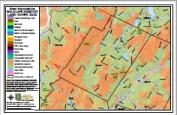 LYMAN’S WILDLIFE HABITAT COVER
Identifying the type of land cover in an area provides useful information as to what wildlife is supported there. Lyman is rich in Northern Hardwood-conifer and Hemlock hardwood-pine land cover, interspersed with areas of Marsh and Shrub Wetland and Open Water. Conservation and public land offer the potential for connecting these areas to better support wide ranging wildlife.
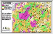 LYMAN’S HABITAT RANKED BY IMPORTANCE
Information about habitat condition was analyzed by NH Fish and Game and its conservation partners to develop a ranking system for identifying the highest quality habitat in New Hampshire. Lyman is home to a large area of highest ranked habitat for wildlife. This information can be used to determine how best to manage/conserve your property and to support the wildlife in those critical areas.
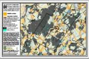 LYMAN’S WILDLIFE CORRIDORS
Wildlife moves to meet its needs such as finding food, reproducing, migrating between winter and summer habitats, and dispersing to a new territory. A wildlife corridor is a habitat linkage that joins two or more areas of wildlife habitat, allowing for movement from one area to another. The NH Wildlife Corridors map shows corridors that connect core areas of wildlife habitat and can be used by conservation planners, landowners, land trusts, biologists, and others.
To see the maps at full scale, click on the desired picture.